The idea of a “safe” state in a nuclear emergency does not hold up under expert scrutiny. Fallout maps can show where immediate radiation exposure may be lower in one modeled scenario, but they do not erase the broader dangers of infrastructure failure, contaminated supplies, and climate effects that reach far beyond any single state line.
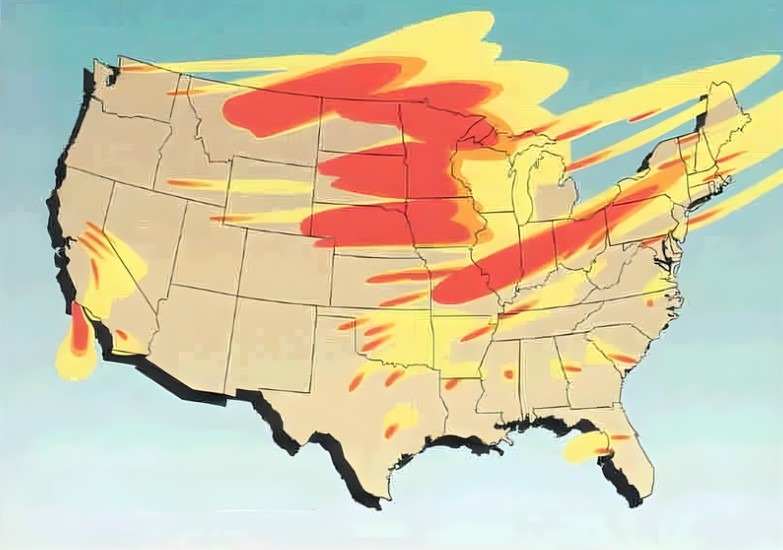
Even so, location matters in the first hours and days. Simulations built around attacks on U.S. missile silos found that some states repeatedly landed in lower-exposure zones, mainly because of distance from silo fields and the way winds tend to carry fallout.

1. Maine
Maine appears in the lower-risk group in both average-case and worst-case fallout modeling tied to strikes on inland missile silos. Its distance from the central U.S. silo belt matters, and so does the fact that fallout from ground bursts tends to follow the wind in an elongated pattern rather than spreading evenly in all directions. In the lower-exposure band, modeled doses fell between 0.001 Gy and 0.5 Gy in average conditions, with Maine still remaining in the lower tier in harsher wind-driven scenarios.
2. New Hampshire
New Hampshire repeatedly shows up among the less affected states in the same simulations. That does not mean immunity. It means the state is outside the regions projected to absorb the heaviest immediate fallout from attacks on silos in states such as Montana, Wyoming, Colorado, Nebraska, and North Dakota. Federal guidance on radiation emergencies stresses get inside, stay inside and stay tuned, because even lower fallout exposure still requires prompt sheltering.
3. Vermont
Vermont benefits from the same geographic advantage as the rest of northern New England in these models: it sits far from the most likely silo targets in the Great Plains. Scientists measure exposure in grays, and the gap between regions can be dramatic. While the most exposed areas in some simulations ranged up to 84 Gy, Vermont stayed in the lower category in both the average and worst-case maps examined from the silo-attack scenario.

4. Massachusetts
Massachusetts lands in the lower-risk cluster because the modeled attack is centered on land-based missile fields, not on every possible strategic target in the country. That distinction matters. The map does not describe a full national exchange with every military and industrial target involved. It reflects one type of strike, and in that narrower frame Massachusetts remains one of the states with comparatively lower four-day fallout exposure.

5. Rhode Island
Rhode Island’s small size does not change its placement in the lower-exposure group. In these simulations, the biggest factors are target location and wind. Fallout from a ground-level nuclear detonation can travel hundreds of miles, but concentration falls as it spreads and as time passes. That pattern helps explain why distant coastal states can rank better than inland areas much closer to missile silos.

6. Connecticut
Connecticut remains in the lower tier across the two scenarios highlighted in the source material. That consistency is one reason New England draws so much attention in these discussions. A longer view, however, changes the picture. Experts cited in the reporting warned that lower immediate fallout does not shield any state from food disruption, water contamination, or the wider consequences of a large nuclear exchange.

7. New York
New York is included in the less affected group in both average and worst-case silo-strike models. This is one of the clearest examples of how a state can be relatively better positioned in one model while still facing serious danger in reality. Fallout predictions are highly sensitive to daily weather, and broader targeting assumptions could alter the risk picture substantially. One expert told Newsweek, “Nowhere is truly ‘safe’ from fallout and other consequences like contamination of food and water supplies and prolonged radiation exposure.”
8. New Jersey
New Jersey also falls into the lower-exposure bracket in the reviewed maps. That placement reflects a narrow but important principle: the heaviest immediate danger concentrates near the blast zone and downwind from it. According to the modeled data summarized by average radiation exposure after four days, New Jersey sits well below the exposure levels projected for the most endangered central states.
9. Florida
Florida rounds out the list because it remains in the lower-risk group in both the average and worst-case scenarios tied to silo attacks. Its distance from the northern Plains and central missile fields helps. But preparedness matters more than rankings. FEMA guidance notes that after a detonation, people may have 10 minutes or more to reach adequate shelter before fallout arrives, and the safest place is deep inside a sturdy building, ideally below ground if it can be reached quickly and safely.
These states stand out only in a very specific modeling exercise: attacks focused on U.S. missile silos. They are not guaranteed refuges, and they are not insulated from the national and global consequences that experts say would follow any nuclear conflict.
The more useful takeaway is practical rather than geographic. A household plan, a reliable way to receive alerts, and a basic understanding of sheltering can matter more in the first day than a map ever could. For broader public context, fallout studies have also linked silo attacks to several million deaths in some models, while longer-term climate impacts remain a separate and far larger threat.


